


![]()

Set Color:
![]()
![]()
![]()
Search Narco News:
Narco News Issue #54
Complete Archives

Sign up for free email alerts list: English
Lista de alertas gratis:
Español
Contact:
Publisher:
Al Giordano
Opening Statement, April 18, 2000
¡Bienvenidos en Español!
Bem Vindos em Português!
Editorial Policy and Disclosures
Narco News is supported by:
The Fund for Authentic Journalism
Site Design: Dan Feder
All contents, unless otherwise noted, © 2000-2011 Al Giordano
The trademarks "Narco News," "The Narco News Bulletin," "School of Authentic Journalism," "Narco News TV" and NNTV © 2000-2011 Al Giordano
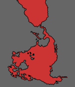
Geographic Survey Project of the Sierra Juarez Mountains Stirs Protests
In Oaxaca, Geographers Deny Surveillance Charges
By Nancy Davies
Commentary from Oaxaca
February 21, 2009
I. Accusations
Amid a storm of accusations, defenses, campus condemnation, public pronouncements and news articles, the Union of Organizations of the Sierra Juarez of Oaxaca (UNOSJO) has condemned the mapping project called Mexico Indigena, a sub-project of Bowman Expeditions. The founder and director of UNOSJO, Aldo Gonzalez, launched a campaign to alert indigenous communities of Mexico and the world to the risks involved in giving access to Bowman Expeditions under whatever name.
What is the true reason for a geographic survey of the Sierra Juarez paid for by both the US and Mexican governments? Many possible reasons come to mind, such as theft or purchase of forest timber, locating natural resources like minerals or water, narcotics activities, bio-piracy, counter-insurgency, geo-piracy, and preparing for privatization of communal land. UNOSJO’s press release discusses several possibilities.
The American Geographical Society (AGS) director, Jerome Dobson, asserts that academics commonly accept US Army funding, and hand over their results with no qualms. AGS sponsors Bowman Expeditions in places like Columbia and Jordan. Gonzalez advises other communities not to permit such mapping projects. “You’ll be sorry,” he asserts. It is not yet clear what the Mexico Indígena project sought in the Sierra Juarez.
 Aldo Gonzalez showing map D.R. 2009 |
Gonzalez claims the investigation in the Sierra Juarez failed to inform the population regarding two aspects of its funding: the US military; and Radiance Technologies, a weapons business.
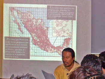
Although the Mexican government clearly participated and partially funded the project through its two agencies, Semarnat and PROCEDE, it has thus far made no statement in the face of accusations launched against the Mexico Indígena Project.
Gonzalez claims a possible violation of national sovereignty and violation of the autonomy of indigenous peoples. For all that, he has refrained from asserting as if it were proved, that the Mexico Indígena team was spying.
Spying? Bowman Expeditions has been in Iraq and Afghanistan with “embedded” sociologists, psychologists, and geographers. These teams gather terrain and cultural intelligence to make easier the task of the military, who can use information regarding the culture, family relations and psychology of the local people, as well as close details of streets and passages. According to Wikileaks, posted on December 11, 2008, a 122 page handbook dated September 2008 presents the US military’s controversial anthropology based counter-insurgency techniques. Formally titled “Human Terrain Team Handbook” the document comes out of the US Army’s $190 Million “Human Terrain System” [HTS] program. According to the handbook, Human Terrain Teams are 5-9 person intelligence teams made up of serving military, contractors and “academicians”. The teams are designed to assist a commander’s irregular warfare operations by using anthropological and intelligence techniques to exploit cultural, political and family relationships in a region. The material is unclassified, but has not been publicly released though official channels.
So is Mexico Indígena a Human Terrain System (HTS) project? Both use human participation. Geographers and academics are in the area to gather on-the-ground information with local input. Most important: they have the same parent origin and funding source. UNOSJO soon discovered that Mexico Indígena is a Bowman Expedition, like those carried out in San Luis Potosi, México; the Antilles; Colombia, and Jordan; all are sponsored and financed by the Foreign Military Studies Office (FMSO) of the US Army, among others. FMSO prepares a world data base which is an integral part of the HTS used for counterinsurgency by the US Army, and which could be used against indigenous pueblos or anyone else involved governments choose.
II. The History
The Mexico Indígena project team approached UNOSJO in 2006. That would place the Sierra Juarez in the same time frame with Human Terrain Systems or Human Terrain Teams (call it what you will) in Iraq, and the rise of the popular social movement in Oaxaca. The local population, perhaps 10,000 persons whom UNOSJO is identified with in the remote Sierra Juarez of Oaxaca, is Zapotec; many of the people in the mapped towns of San Juan Yagila and San Miguel Tiltepec don’t speak Spanish. Other towns initially approached were friendly to the project but then had second thoughts. According to Melquiades Cruz Miguel, a native of Yagavila, many people saw something fishy behind the project’s offer to give the local people maps of their lands and to train young people in mapping. No one promised to reciprocate actual information; indigenous people in the past have supplied valuable information to investigators and received in return, as now, only a map or a book.
Aldo Gonzalez launched his initial complaint through Noticias, the Oaxaca newspaper, on January 16, 2009. This article discloses the funding of México Indígena by the Foreign Military Studies Office (FMSO). Violation of indigenous people’s rights comprised the sole initial complaint, others took up the cause as spying. Jerome Dobson denies that Mexico Indígena relates in any way to mapping projects in the Middle East, despite the fact that Bowman Expeditions sponsors both. I doubt Gonzalez foresaw the subsequent outrage of activists, intellectuals and academics. The initial Noticias piece was followed by an opinion piece by Ernesto Reyes the next day, and soon an article by Silvia Ribeiro appeared in La Jornada out of Mexico City on Saturday January 31, 2009. The horse was out of the barn and everyone ran in all directions.
Both Dobson and Peter Herlihy, the lead geographer for the Mexico Indígena project, defended themselves. In his February 5 response, Dobson mounted a counterattack including a condescending denigration of all protesters, and of Aldo Gonzalez in particular. In his scathing open letter Dobson uses half truths and time confusions so that only a knowledgeable person could pick apart when events occurred. He used words like “cyberbullying” and “midnight Ninja”. He complains, “...one negative comment arose from a individual with no legal or political standing whatsoever in the village, and his message went viral. It irks me …Anyone who visits our web site, reads our vitae and publications… or attended our many presentations at academic conferences in the U.S. and Mexico already knows we bent over backward to do the right thing. “
Dobson rhetorically asks: “Are Bowman Expeditions connected with Human Terrain Systems (HTS)? Absolutely not. We have never requested and never received any funding whatsoever from HTS. As I understand it, HTS is totally the domain of anthropologists. Our expeditions are the domain of geographers.” Dobson ignores that both, funded by the US Army, are part of the same global mapping strategy. Only the names change.
He denies that Aldo Gonzalez “legally or politically represent(s) the people of the rural villages” and says, “No. He is simply the director of a small NGO called UNOSJO, based in Gueletao (sic)... Our study area and our field office are located in the municipality of Ixtlan. Gueletao (sic) is a distinctly separate municipality completely unaffiliated with Ixtlan. Both towns are located about five hours drive from the villages in question…”
To say that Gonzalez does not legally or politically represent the people ignores that in communities guided by usos y costumbres “legal or political representation” is unknown. UNOSJO works among and with its own people. As Cruz Miguel put it, “UNOSJO doesn’t take decisions in contradiction to the local assemblies.” This part of the Sierra Juarez is, in and of itself, a community of indigenous people with a common heritage and language. As for the towns mentioned, the Mexico Indígena office set up in Guelatao but moved after Gonzalez became suspicious.
Dobson offers the “everybody’s doing it” argument: “Should American researchers accept funding from the U. S. Department of Defense? Opinions vary, but large numbers do accept DoD funds” . Dobson continues with this amazing assertion: “I would also counter that many people of goodwill criticized President Bush for his refusal to engage with the government of Iran. How can scholars with desperately needed knowledge and skills now refuse to engage with our own government?”
Huh? Does this concede that the geographers are engaged with the US government? He claims the information was “handled in a secure and responsible manner”, with no mention that monthly reports went to FMSO. By the time the communities received their printed versions of the maps in November of 2008, the maps were already on internet sites as well as in the hands of the US Army.
Dobson states: “If anyone claims we have violated our own guidelines, surely any fair-minded peer will demand proof. “ Aldo Gonzalez, in his press conference of February 19, listed such violations, including failure to disclose the funding source, and inaccessibility (i.e. the internet sites are not in Zapoteco), and that personal information was gathered.
Dobson further defended the project by claiming that they were simply establishing property boundaries, issuing certificates to the persons whose land has been mapped. That occurred in San Luis Potosi, not in the Sierra, and sadly suggests that private ownership might come to a communal area. That would coincide with the expressed desires of the Mexican government.
Dobson put the last nail in his “goodwill” coffin with a statement extolling the “benefits” of Bowman Expeditions as “the modern incarnation of a long-standing AGS mission to serve Latin America. From 1925 to 1945 we mapped all of Latin America from the U. S. border to Tierra del Fuego at 1:1,000,000 scale. ...Those maps were essential to the beneficial development of the region…Convinced that geographic ignorance has been the cornerstone of U. S. foreign policy since the end of World War II, I asked myself what the American Geographical Society could do about it. I conceived of sending a team of geographers to every country in the world to improve geographic understanding, connect with scholars, and bring back that knowledge to the American people. I did a calculation and was astounded to realize that it would cost only $125,000,000 to send a professor and two or three graduate students to every country in the world to spend a full semester every year. ... This is the noble effort that Gonzalez is trying to quash in one part of the world, in direct opposition to the people who live there. Readers should ask why.”
Dobson’s “noble efforts” are questionable.
III. Brief Correspondance with Herlihy
I wrote an email to Peter Herlihy, asking how he happened to become interested in mapping the Sierra Juarez, and received in part the following: “The proposal to extend our work to Oaxaca came from a presentation we gave on our methodology and the project at a seminar on participatory GIS [this is Geogaphic Intelligence Systems]at the Unidad Academica Foranea de Geografia-Morelea, antecedent of the CIGA-UNAM. [This was in 2005] As the seminar and associated field exercises progressed, one student Gustavo Ramirez, a Oaxaca teacher(sic) with relatives in the Zapotec community of Ixtlan de Juarez, became very interested in the possibility of bringing the Mexico Indígena participatory mapping project to the Sierra Juarez of Oaxaca and he, in fact, suggested we explore research there, because we knew nothing of the region and had never visited it before…We thought that the region would provide a great comparative study area for understanding the impact of the neoliberal land reforms and the PROCEDE certification program on indigenous lands, which was our research focus. Mr. Ramirez first traveled to the region with us and became our project’s indigenous coordinator. He introduced us to UNOSJO, but due to the difficult political situation in the region and the rise of the APPO movement at the time, and as explained in our extended statement, we found a new coordinator and distanced our project from UNOSJO and the broader regional politics…”
In 2005, Ramirez was participating in a course given by a then-named Geographic Foreign Academic Unit, now called Centro de Investigaciónes en Geografía Ambiental (CIGA-UNAM). Herlihy and his team were invited to participate in the course, about Participative Satellite Intelligence Gathering (SIG-P). According to Herlihy’s letter, the SIG-P methodology roused the interest of “one of the students, who was enjoying a sufficient political leadership to help the Herlihy team in a project similar to that of the Huasteca of Potosi.” That “student” was Gustavo Ramírez and the Potosi Huasteca project involved privatization of lands.
A similar defense was issued by Pedro Sergio Urquijo Torres of the Center of Geographic Information at the Autonomous University of Mexico (CIGA-UNAM), and sent Wednesday February 2, 2009 to his fellow academics. Urquijo Torres describes PROCEDE as a government program with the goal of privatizing the lands of the campesinos and admires the work Herlihy did in Huasteca Potosi for delimiting their lands. He writes: “One of the factions of the movement [the 2006 social movement] certainly opposed to Gustavo Ramírez, saw the opportunity to strike at the student (sic) Ramírez through the geographers. It [one faction] had (and has) everything against them: “gringos” making maps in a conflicted indigenous zone and with high potential for their exploitation. ...The dirty political game of the Oaxaca indigenous organizations [italics mine] not only has put in question the form in which we work on geography, but also has affected the personal life of our colleagues. The office of Herlihy in Kansas was taken over by students in solidarity with “the affected communities”, [see this link] and his reputation [has been affected]... Participative Satellite Intelligence Gathering – [SIG-P] is not, in any way, “a weapon of war” ...”
The Oaxaca social movement was underway when the Mexico Indígena project arrived in 2006. Hence “they distanced themselves” from the coordinator, Aldo Gonzalez, who is a movement activist. The UNOSJO press release refers to “coincidences” and states (my translation) “The geographic team arrived in Oaxaca to begin its investigations in the summer of 2006, just when the Asamblea Popular de los Pueblos de Oaxaca (APPO) had been formed. The APPO is mentioned in reports that the Mexico Indigena team sent to the FMSO Status Report, July 2007. It is also mentioned in these reports that the communities of Zoogochi and Yagavila suspended their cooperation with the geographers for “the support of some sympathizers of the APPO.”
IV. Interview with Gonzalez
I spoke privately with Aldo Gonzalez on February 11, 2009. He assured me that Mexico Indígena never mentioned FMSO nor Radiance Technologies, a high tech weapons manufacturer. Gonzalez said he became suspicious because the goal of the project was never made clear. PROCEDE’s stated purpose under Mexican law is to examine land boundaries, especially when privatizing land parcels. Ejido parcels are individually owned, but without legal deeds. They belong to a community but are not communal. With the community’s consent they can be sold. In contrast, this corner of the Sierra Juarez is not ejido; it is communal. PROCEDE provided either a disguise or a forewarning of privatization to come.
And why do these towns need maps, since they know their own territories? Gonzalez stated that if the culture were dying out, or the language was being lost, that would justify getting all this in writing, but since that is not the case, the maps are solely for the benefit of outsiders.
According to Aldo Gonzalez, his first contact with the Mexico Indígena project came via Gustavo Ramirez, a biologist and also a Zapoteco from Ixtlán, whom Gonzalez knows. Ramirez, in Gonzalez’ opinion, is a PRD (Spanish initials for the center-left Democratic Revolution Party) political operative. He was Director General of the Biological Corridor Project for Mesoamerica, formerly called Plan Puebla Panama, but he resigned after a few years. Others who know Ramirez praise his work in environmental protection.
 Aldo Gonzalez with APPO members D.R. 2009 |
Herlihy’s team enrolled the two villages which stayed with the project, Yagila and Tiltepec with conversations translated from Zapoteco to Spanish to English, and back. These two villages received electronic printed copies of community maps they helped produce. The maps were already out on the internet, and, therefore already in the hands of the FMSO. The map internet sites are in English, not Spanish or Zapoteco. But, Gonzalez points out, the topographical places and names of geographical features and plants were asked for in Zapoteco. So, for example, if the map shows a town named Guelatao, if you know Zapoteco, you would know there is a lagoon in Guelatao, because Guelatao means beautiful lagoon. For those not familiar with Zapoteco, embedded information such as “rocky hill” or “water plant” would not be readily accessible, but for those who can translate the language, the maps serve as a detailed description.
In addition, these Mexico Indígena maps also name families living on some described parcels, despite the Yagila people expressly demanding they not be published. A recent publication of the AGS photos show members of the communities and members of UNOSJO. The bland and pretty (my opinion) Kansas University site. The UNOSJO press release states, “The report (of Mexico Indigena) mentions that the Herlihy team continued processing data collected in Zoogochi and Yagavila after they decided to leave the project. This of course constitutes a clear violation of the will of the people who initially assisted the investigation.
“If we note the focus that the FMSO has in relation to counterinsurgency, then it does not seem a coincidence that the arrival of the Mexico Indigena team coincided with the growth of the APPO in Oaxaca…although we cannot prove it. The other Bowman expeditions have been carried out precisely in places where insurgency exists and also the strategic interest of the United States as would be Columbia, Kazakhstan and Jordan.”
Click here for more Narco News coverage of Mexico
- The Fund for Authentic Journalism
For more Narco News, click here.